BlueEnergy Build
Hydrological, Hydrogeological and Modelling Studies
BEBPL provides hydrological and hydrogeological services as well. Hydrological and hydrogeological services are related to the study and management of water resources, both on the surface and underground.
BEBPL specializes in delivering comprehensive hydrological, hydrogeological, and modeling studies customized for diverse sectors. Our data-driven solutions are instrumental in promoting efficient water resource management, environmental preservation, and sustainable development.
Water Resource Management:
- Hydrological Studies: Our hydrological assessments, including flow monitoring, river discharge measurements, and rainfall data analysis, provide invaluable insights for optimized water allocation and reservoir management.
- Hydrogeological Studies: Groundwater assessments, well drilling, and hydrogeological models ensure efficient underground water resource management.
Environmental Impact Assessments:
- Hydrological Studies: River basin assessments collect data on water quality, flow dynamics, and ecological factors, supporting environmental impact assessments.
- Hydrogeological Studies: Crucial for aquifer characterization and assessing contaminant transport, hydrogeological models predict the spread of contaminants and assess aquifer vulnerability.
Agriculture:
- Hydrological Studies: Soil moisture surveys and hydrological modeling aid in irrigation planning and water-efficient agriculture.
- Hydrogeological Studies: Groundwater assessments ensure sustainable water sources for crops and livestock.
Urban Planning:
- Hydrological Studies: Urban drainage surveys and hydrological models are essential for designing drainage infrastructure and managing flood-prone areas in urban planning.
- Hydrogeological Studies: Subsurface investigations guide sewage system design and assess groundwater contamination risks in urban areas.
Construction and Infrastructure:
- Hydrogeological Studies: Foundation studies assess soil and subsurface conditions, ensuring safe construction practices.
- Hydrological Studies: Site-specific hydrological investigations examine water conditions during construction, aiding in drainage planning and erosion prevention.
Energy and Hydropower:
- Hydrological Studies: Hydropower potential surveys assess water availability and flow rates, aiding in the design and operation of hydropower plants.
Ecology and Conservation:
- Hydrological Studies: Ecosystem surveys collect data on water quality and flow dynamics in natural habitats, supporting biodiversity and conservation.
- Hydrogeological Studies: Assessment of water flow changes in aquatic habitats guides conservation efforts.
Climate Change and Research:
- Hydrological Studies: Climate impact studies predict the impact of climate change on water resources, vital for adaptation and mitigation strategies.

Hydrological Studies:
Hydrological studies are a critical component of water resource management and environmental assessment. These studies focus on understanding the movement, distribution, and quality of surface water, primarily in rivers, lakes, and streams. Here are the key aspects of hydrological studies:
Flow and Discharge Analysis: Hydrologists collect data on river flow and discharge, which involves measuring the amount of water passing through a specific point over time. This data is essential for assessing water availability and planning water resource management.
Rainfall Analysis: Hydrologists analyze rainfall patterns and data to understand the input of water into the hydrological system. This information is crucial for predicting and managing flood risks.
River Basin Studies: River basin studies encompass a broader analysis of entire river systems, examining factors like water quality, flow dynamics, and ecological conditions. These studies support environmental impact assessments, particularly in projects affecting river ecosystems.
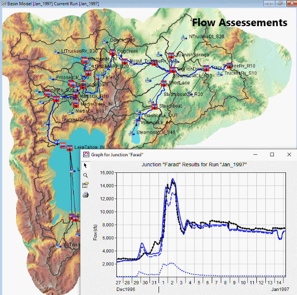
Hydrological Modeling: Hydrologists use computer-based hydrological models to simulate water flow, predict river behavior under various scenarios, and optimize reservoir management. These models are valuable for designing efficient water allocation strategies and flood control measures.


Hydrogeological Studies
Hydrogeological studies delve into the subsurface, focusing on groundwater resources and geological formations. These studies are essential for assessing groundwater availability, quality, and vulnerability to contamination. Key components of hydrogeological studies include:
Groundwater Exploration: Hydrogeologists conduct investigations to locate and assess underground water sources. These studies involve drilling wells, monitoring water levels, and assessing aquifer characteristics.
Contaminant Transport Analysis: Hydrogeological studies assess how contaminants move through groundwater systems, helping identify potential risks to water quality. This is vital for environmental impact assessments and land development planning.
Aquifer Characterization: Hydrogeologists aim to understand the geological properties of aquifers, such as permeability and porosity. This information guides sustainable water extraction and well construction practices.
Hydrogeological Modeling: Computer-based models simulate groundwater flow, helping predict the movement of water in aquifers. These models aid in optimizing well placement and sustainable groundwater management.


Modelling Studies
Modeling studies involve the use of mathematical and computer-based models to simulate various aspects of hydrological and hydrogeological systems. These models are powerful tools for predicting future behaviors and assessing the impact of different factors on water resources. Key components of modeling studies include:
Hydrological Modeling: These models simulate river flow, water availability, and reservoir management. They are vital for optimizing water resource allocation and planning flood control measures.
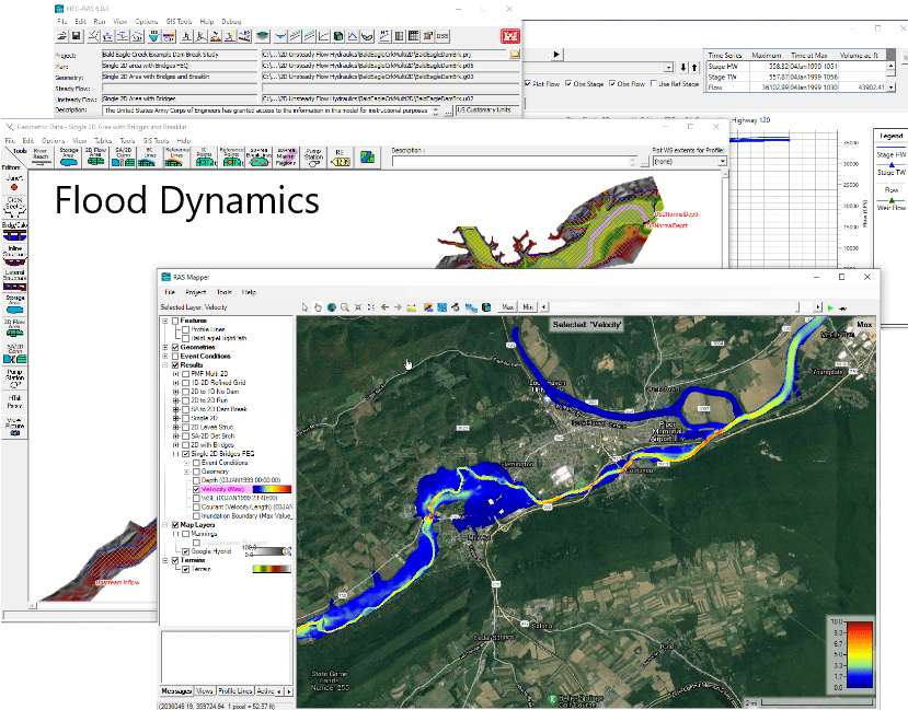
Hydraulic Modeling: Hydraulic models focus on the flow of water through pipes, channels, and structures. They help design effective drainage and sewage systems, as well as flood protection infrastructure.
Groundwater Modeling: Groundwater models predict the movement of water within aquifers, enabling the assessment of groundwater availability and vulnerability to contamination.
Environmental Impact Assessment Modeling: These models predict the impact of development projects on aquatic ecosystems and groundwater resources, aiding in environmental impact assessments and conservation efforts.